

Application map (VRA)
The application map (VRA = Variable Rate Application) divides the field into zones with a different application rate in each: fertiliser, herbicide, plant-protection product. DroneField builds one from your vegetation index in just a few clicks.
What it’s for
Section titled “What it’s for”The core idea of precision agriculture: apply more where the plants need it, and less or none where they don’t. Typical applications:
- Nitrogen fertilisation — more N to weaker stands
- Herbicide — only where weeds are (Spot Spraying)
- Seeding — for row-crops on heterogeneous fields
- Soil-sample zoning — split the field into NDVI-similar zones to plan where to sample
Starting
Section titled “Starting”- Processing must have finished — at least the vegetation index needs to be available.
- Draw (or import) a field boundary — this defines the application grid’s outer contour.
- On the boundary toolbar click Application.
A new panel opens at the bottom of the map: Application map.
The application map panel
Section titled “The application map panel”The panel contains:
Grid settings
Section titled “Grid settings”- Cell size — one cell’s size in metres. Recommended: 5 × 5 m — supported by most drones and ground machines. Smaller cells (e.g. 3 × 3 m) are more detailed but produce more cells; larger cells (e.g. 10 × 10 m) are coarser.
- Rotation — rotate the grid relative to the field. If the field and rows are tilted 30° from the axes, enter that here.
- Grid coverage — does it fully cover the field? (default 100%)
The Generating grid… progress bar shows when the panel is rezoning the field.
Since version 26.4, manual zones work with index bands instead of an equal-area split: you set a min–max index value per zone, and each grid cell lands in the zone whose band contains its average.
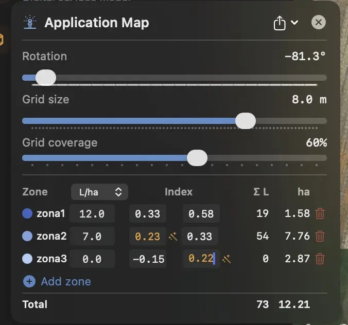
Each zone has:
- Name — e.g. Weak stand (default: Zone 1, Zone 2 …)
- NDVI / NDRE / GNDVI band — the min–max index range of the zone
- Dose — l/ha (liquid) or kg/ha (solid, seeds); the unit selector shows one column at a time
- Colour — for visualisation
How the bands behave:
- A new plan starts with two zones: Zone 1 covers the whole positive band, Zone 2 is the “no treatment” zone (0 l/ha) — it always stays lowest, and it automatically receives the practically lifeless cells (bare soil, dried residue) as well.
- Add zone inserts the new zone just above the lowest one by splitting the band above it — every value can be overwritten.
- Overlapping bands turn red, a gap between bands turns orange. The magic-wand button next to the field snaps the neighbouring zone’s band to yours — the value you typed is never lost.
- If you edit the bands of an AI-generated plan (AI vegetation analysis), you take over manual control of the zoning.
Statistics
Section titled “Statistics”At the bottom of the panel:
- Zone 1: 3.2 ha — area of each zone
- Total: 12.5 ha — total area of the field (with grid coverage)
These update live as you change the ranges.
Export
Section titled “Export”The panel’s Export menu:
XAG Spot Spraying
Section titled “XAG Spot Spraying”A special XAG drone mode: the field is split into zones, and the drone sprays only the marked spots. Optimised path, less chemical.
Before export a confirmation dialog shows the final zone picture — click Yes to finalise. For XAG Spot, Hardi and ABZ exports the confirmation panel now summarises per dose (colour + dose + area in hectares) instead of listing every polygon; the polygon count appears in a single summary row.
XAG VRA precision map
Section titled “XAG VRA precision map”Conventional VRA: the drone sprays continuously, but the dose varies by zone.
DJI VRA precision map
Section titled “DJI VRA precision map”For DJI Agras T20 / T30 / T40 / T25 / T50 drones. Same principle as
XAG VRA. DroneField creates the full Exports/DJI/ sub-structure
(KML/, ShapeFile/, Rx/) — copy this to the USB root as-is.
Details:
Field boundaries → Exports/ folder layout.
⚠ Don’t export a standalone boundary KML for the same field when you’re shipping a VRA map — the Rx map’s companion Shapefile already includes the boundary, and the DJI controller would list the field twice.
Video guide: create a precision map and import it into the DJI T30 remote controller:
Hardi VRA Shapefile
Section titled “Hardi VRA Shapefile”The standard for Hardi and other large tractor sprayers in ESRI Shapefile format (WGS84). Loadable in any European farm-controller software (CCI 1200, Trimble, Müller).
ABZ Innovation (L-S series)
Section titled “ABZ Innovation (L-S series)”Exports the field boundary and — for variable-rate jobs — the prescription map (Rx) in the format that ABZ Innovation L-S series spray drones read.
- Choose ABZ Innovation (L-S series) in the export menu.
- Set an Output name for the export.
What you get:
- A
<Name>_Boundaryfolder — the field outline, with obstacles included as cut-outs. - For variable-rate jobs an
<Name>_Rxfolder with the prescription zones: each area carries one rate, areas don’t overlap, and the rest of the field is included as a zero-rate area.
Two things worth knowing:
- Simple whole-field jobs: if the field has no variable-rate zones, the export contains only the boundary — you then set the payload and application parameters on the drone / controller.
- No-spray zones are included in the prescription as zero-rate areas automatically.
PNG / JPEG
Section titled “PNG / JPEG”A visual image of the application map — for presentations, client emails.
Step-by-step workflow
Section titled “Step-by-step workflow”A typical N-fertilisation workflow:
- Survey — drone flies, M3M, ~5 cm/px (or 3–5 cm/px for NDVI), in good weather (overcast around midday).
- Import + Processing — multispectral enabled.
- NDRE map — switch to NDRE in the vegetation index panel.
- Range — e.g. Stress preset (0.30–0.65).
- Field boundary — draw it or import the contour.
- Application map — boundary toolbar’s Application button.
- Zones:
- Zone 1:
0.30–0.45→ 180 kg/ha (low — weak) - Zone 2:
0.45–0.55→ 120 kg/ha (medium — average) - Zone 3:
0.55–0.65→ 80 kg/ha (low — already healthy)
- Zone 1:
- Export — DJI VRA precision map onto the tractor’s USB stick.
- Start with the recommended 5 × 5 m grid — supported by every drone and ground machine. Only go below 3 × 3 m if the machine’s documentation requires it.
- Don’t add too many zones — 3–5 is typical. Too many overcomplicate the operator’s job.
- Always check the confirmation image — tiny zones (1–2 cells) or isolated dots are often noise; consider excluding them.
- Save as a template for the next season — the zoning parameters can be reused, only the data refreshes.
What NOT to do
Section titled “What NOT to do”- Don’t rely solely on NDVI for N fertilisation of mature stands. NDRE is better.
- Don’t use no-spray zones for dose marking — those are for drone-safety, not application.
- Don’t forget to verify the export on the tractor / drone terminal — formats can be strict about encoding, and one wrong setting can ruin the run.